Adding a Upscaling node
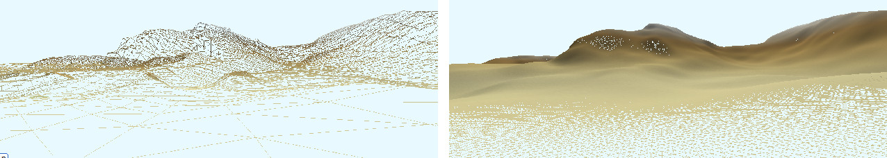
The Upscaling node is used to increase the resolution of a terrain. It is particularly suitable for downloaded terrains, for example from the World browser window, which often have low resolution. It allows you to add details to the terrain as noise.
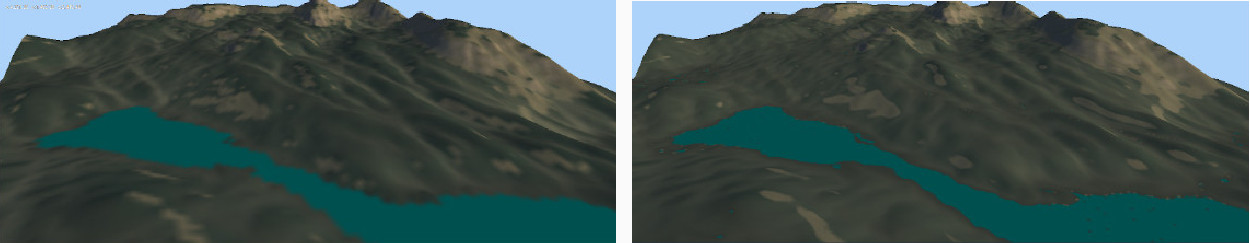
You can also set the sea to an altitude of 0 and detect the lakes (flat surfaces) to avoid adding details to them.
Use with a Colorize
Satellite node to render your terrain easily.
To add a Upscaling node, right-click in the Graph Editor and select Create Node > Terrain Transformation > Upscaling.
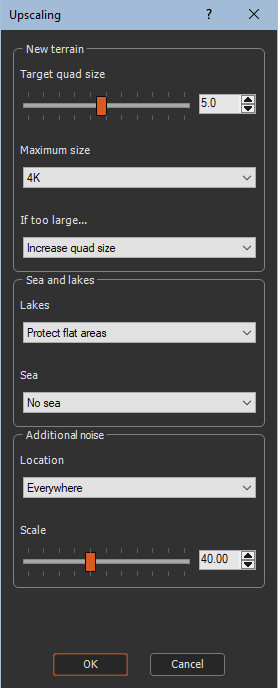
Select the node to open its parameters:
Editing a Upscaling node
- Target quad size: Defines the new resolution of the terrain, i.e. the distance in meters between two vertices, using the slider.
The default size is 5 meters. If the starting terrain has a resolution of 30 meters, it means that the number of terrain vertices will be multiplied by 6 x 6 = 36. If the starting terrain has a size of 1000 x 1000, the new size will be 6000 x 6000. If we choose a resolution of one meter, we end up with a terrain of size 30,000 x 30,000, which is very large.
- Maximum size: To avoid ending up with terrains with too many points, you can limit the number of vertices with the Maximum size parameter.
-
In Instant Terra, the following sizes are available:
- 1K, i.e. a maximum size of 1024 x 1024
- 2K, i.e. a maximum size of 2048 x 2048
- 4K, i.e. a maximum size of 4096 x 4096
- 8K, i.e. a maximum size of 8192 x 8192
Additional values may be available depending on your license.
- If too large: If the expected size of the
output terrain exceeds the maximum authorized size, you can decide
what happens.
- Increase quad size: The value of the quad size is adjusted upwards so that the size of the terrain in number of vertices does not exceed the maximum authorized size.
- Crop terrain: The quarter edges of the terrain are removed so that the size of the resulting terrain does not exceed the maximum authorized size. This option can lead to removing a large part of the terrain and keeping only its center.
- Lakes: The Lakes parameter is used to indicate
whether Instant Terra should detect lakes or not:
- Protect flat areas: Instant Terra detects flat surfaces. No details will be added on these surfaces.
- Do not protect flat areas: Flat surfaces are treated like the rest of the terrain.
- Sea: Add a sea at altitude 0 to the terrain if desired: all parts of the terrain below altitude 0 are replaced by a sea at altitude 0.
- Location: Define the location of the details:
- Everywhere: Add details everywhere in the terrain.
- More at highest locations: Add more details on the elevated parts of the terrain.
- More at lowest locations: Add more details on the lower parts of the terrain.
- Scale: Adjust the size of the details to add: very fine, or larger.
Parameters
| Parameter | Use |
|---|---|
| Target quad size | Defines the new resolution of the terrain. |
| Maximum size | Limits the number of vertices. |
| Increase quad size | Adjusts the value of the quad size upwards so that the size of the terrain in number of vertices does not exceed the maximum authorized size. |
| Protect flat areas | Detects flat surfaces. |
| Do not protect flat areas: | Detects flat surfaces. |
| Crop terrain | Treats flat surfaces like the rest of the terrain. |
| Sea | Adds a sea at altitude 0 to the terrain if desired. |
| Everywhere | Adds details everywhere in the terrain. |
| More at highest locations | Adds more details on the elevated parts of the terrain. |
| More at lowest locations | Adds more details on the lower parts of the terrain. |
| Scale | Adjusts the size of the details to add: very fine, or larger. |